Dandeman Dan's Toy Page
Toyota 4Runner & Ham Radio Interests
|

GPS On board Navigation
A GPS navigagtion system is very comforting to have, especially on trails I am not familiar with. Good off road books such as Charles A. Wells "Guide to Moab,UT Backroads and 4-Wheel Drive Trails" include GPS way points in their trail documentation. Nothing spooks me like being deep into a trail and finding the map and physical trail not matching up and beginning to wonder if I've gone off on an undocumented side trail... or wondering if I will remember all the turns if I have to backtrack out due to the trail being blocked. The GPS data really helps eliminate the "sinking feeling" in these situations. Joe Mehaffey and Jack Yeazel's GPS Information Website is one of the best I've found for additional information and comparison tests on the multitude of GPS receivers now available.
GPS Power Supply Considerations
If you really get into using the GPS system and downloading the track data from trips, it becomes a pain for the track data to be broken up into short segments. This will happen everytime the GPS system is powered down and back up, for example when stopping to eat, for fuel or for tourist stops.
I wanted some means for the GPS to stay on when I stop the vehicle for short stops, but after a predefined time, automatically shut the GPS off. The ChargeGuard Model CGD12D shown below was the perfect answer.
CHARGEGUARD Model CG12D
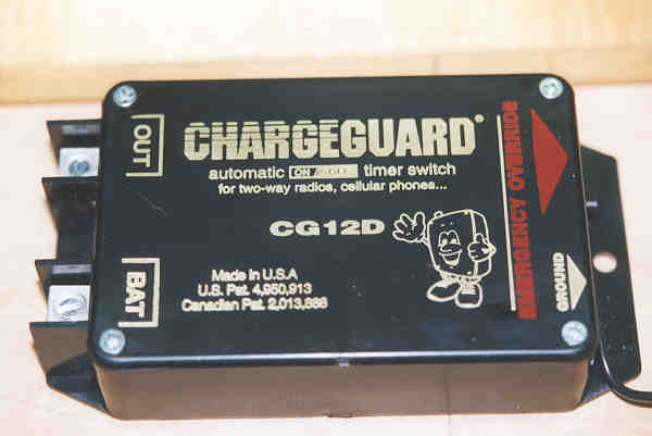
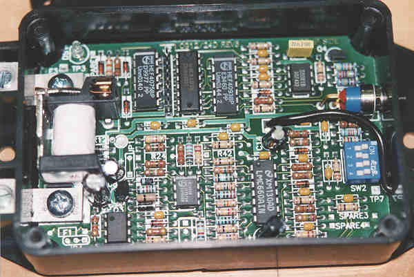
This unit senses when the engine is started and applies power to the connected load. A fused connection to the battery, a ground connection, and connection your accessories are all that is required. The unit is programmable to keep power applied to the connected load from 15 minutes to 15 hours after engine shut down. I have mine set up to shut off the GPS after a 4 hour delay. The ham radio gear is also powered through the unit as the Chargeguard can control up to a 30 ampere load. Shown below is the circuitry, including the programmable DIP switch and relay that carries the load current.
CHARGEGUARD Model CG12D
With this unit, the GPS can now record a full day's driving in one continuous track of data without my being concerned about turning the unit on and off. To prevent stationary track points from filling up the log while the vehicle is sitting still, the distance moved logging option is set in the GPS unit for recording track points. The Chargeguard and GPS current draw is small enough that keeping the system on does present any significant drain on the battery.
Was there Navigation before GPS?
OK, I confess... I'm a navigation junkie, but it's fun, especially on long, cross country trips. Shown below is the method used before GPS units became available. This method, developed partly out of necessity, has evolved into an enjoyable aspect of road tripping.
I've had several things happen in the past that can put a damper on long road trips. First, driving through major metropolitan areas without good route preparation is bad news. The other thing is getting fooled by maps particularly out west, just how far apart places can really be and finding yourself 3 hours away from food, a place to sleep, tired, and running out of daylight.
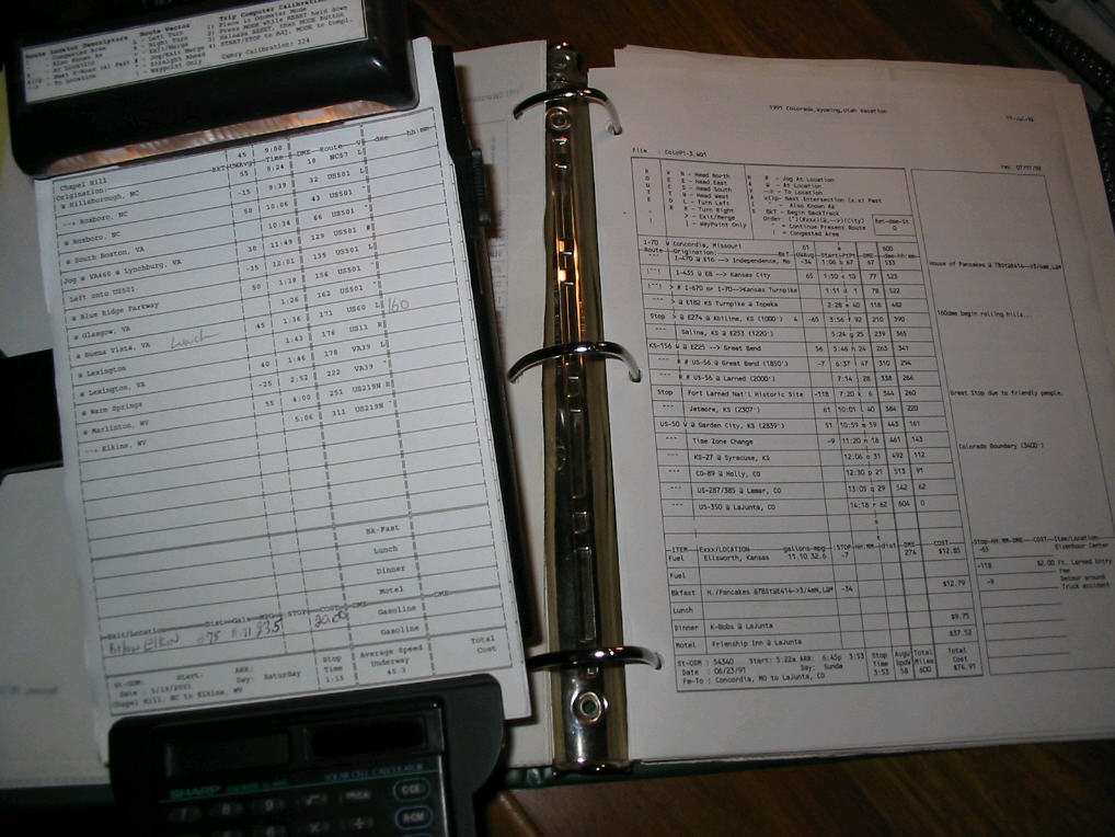
Below is a scheme created from ideas borrowed from aviation route planning, road rallying, and can document a day's driving route in a short concise set of instructions (route, direction, way point, distance traveled). The printouts are a spreadsheet I came up with to plug the routes, distance, projected speeds, planned stops and it would do time calculations and add the cumulative distance. As we did more and more trips, this trip documentation has become our "reference library" for future trip planning.
|
Route Sheet Close up
|
One of the surprises was how close this would turn out to actual travel time and taught me a few simple tricks. For example if you are trying a maintain a 60 mph average and for example you are driving at 68 mph (i.e. interstate driving) and do it for two hours, that lets you do a 16 minute (1 minute gained per hour for each mph over the 60mph average) gas & food stop at the end of the two hours and you'll stay on your 60mph average.
Most of this has been replaced by the GPS, and I kind of miss the hand written notes we would do on the sheets about neat places to eat, stay, tour and places to come back to on the next trip. Shown below is the notebook and a couple of route sheets. The thing on the left is a aviators "knee board" which is handy for reference or note taking while in en route.
Shown on the right is a route sheet. This is one that I updated the spreadsheet with the actuals from one of our trips.. Pretty concise for documenting approximately 550 miles of route and 13 hours of travel/stop time on an approximately 5x5" square of paper. I essentially do the same type of planning, except now it's with MapSource software on a laptop and load the route and way points into the GPS for the day's planned route.
Playing with this enroute makes right seat time much more enjoyable and swapping off the driving about every two hours with the wife helps both of us. Now, in high congestion, difficult navigation areas, I let her drive and me navigate, which works better.
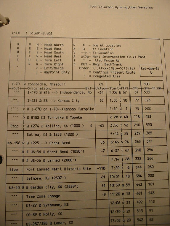
To say in words a few of the lines to the right.. e.g. rows a & b: Today's run starts out of Concordia, Mo, heading west in I-70 with average speed being 61 mph. We stopped at I-470 Exit 8 which was 67 miles or 1hour and 6 minutes down the road, where we made a 34 minute stop for breakfast.
Rows i & j: This is a route jog (which is a standard rallying route term). Here we are following Kansas State route 56 and at the intersection with US 56 at Great Bend (at odometer reading 310, 6:37 hours into the trip, we take a right at the intersection to continue following KS156; looks like we made a brief stop; probably for a driver switch. KS-156 peels away from the US-56 turning right at Larned, at odometer reading 338 and 7:14 hours into the trip. This is a lot of words to say what the chart to the right says in a very compact form.
|
St. Louis, Missouri Metropolitan Area
|
One example of how this kind of info is used, is on one trip out we were leaving the weekend of July 4 and quite concerned about how heavy the the traffic might be, particularly going through congested areas, which are Lexington and Louisville, Kentucky and then St. Louis, Missouri. By having this type of information from a previous trip, we set our departure time from home to put us through these areas at times when traffic would be the lighest.
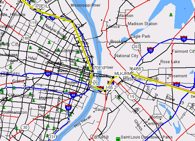
This may be seem like overkill to some, but a cross country trip is a significant investment in time and money and the idea is to enjoy yourself.. I believe falling victim to the "are we there yet" phenomenon is in most part due to lack of things to occupy your mind on a 14 hour driving day. It also helps reduce the pucker factor for example in driving through places like St. Louis, a major metropolitan area and with 4 interstate routes converging down to cross one bridge across the Mississippi River as shown below.
Other Past Travel Toys
OK I've already admitted I a junkie for this stuff, so no apologies for the following either.
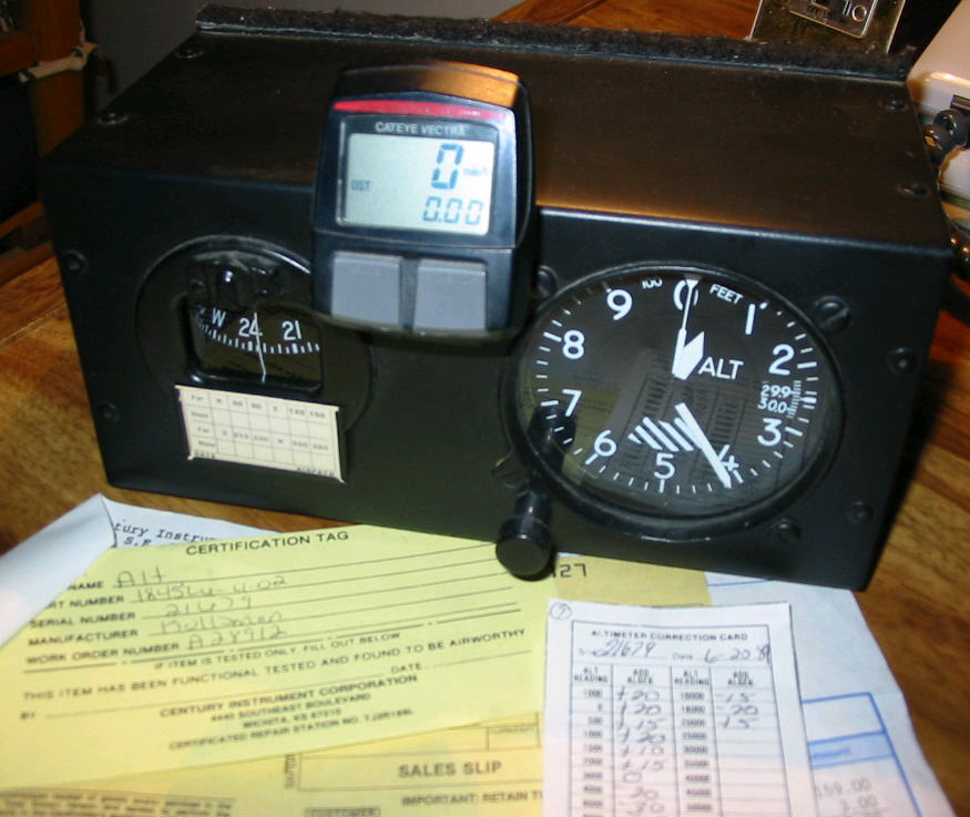
Before GPS systems were available and affordable, I wanted some kind of in vehicle navigation computer system and a few other features like an altimeter and compass. Heres what I came up with...
|
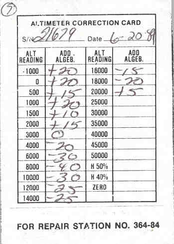
Altimeter Correction Card
|
The compass and altimeter are aircraft instruments and the computer; you probably recognized it off your bicycle. It was the best I could come up with and had most of the trip computer features I was looking for at a reasonable price. One of the really neat features of the bicycle computer is you calibrate it by specifying the wheel circumference in centimeters. It is adjustable in 1 cm increments which can be super accurate and the odometer readings are down to the one hundredth of a mile i.e. every 52.8 feet.
On one trip out west I was able to get it calibrated with the mile marker posts to where it held within a hundredth of a mile for over a 30 mile stretch. As said earlier, you got to have a way to entertain yourself on those long cross country hauls.
The altimeter is a reconditioned, certified for instrument flight accuracy gauge that's really fun to have in the Colorado Rockies. Here is the error correction card for the gauge; a little more accurate than your average after market quality car altimeter. The GPS has replaced this unit on the long trips, but I still miss watching the altimeter wind up with the elevation gain.
One interesting observation is that whether descending a high speed highway at 50 - 65 mph (for example the western slope of Monarch Pass, Colorado), a relatively straight 9% grade; or off road on a steep, but good enough trail to be continuously moving, about 400 feet/minute is pretty much the maximum safe, descent rate.